
Lightning Positioning Software System——YBY-SD35
I.Single-Station Lightning Positioning Overview
1.1 Project Background
As modern society imposes increasingly stringent safety requirements on power systems, communication infrastructure, the aerospace industry, and other sectors, the importance of lightning monitoring and early warning systems has become ever more prominent. As a core component of lightning monitoring systems, lightning location software is responsible for the critical tasks of real-time reception, parsing, and display of lightning-related data, providing crucial decision-making support for safeguarding human life and ensuring the normal operation of equipment.
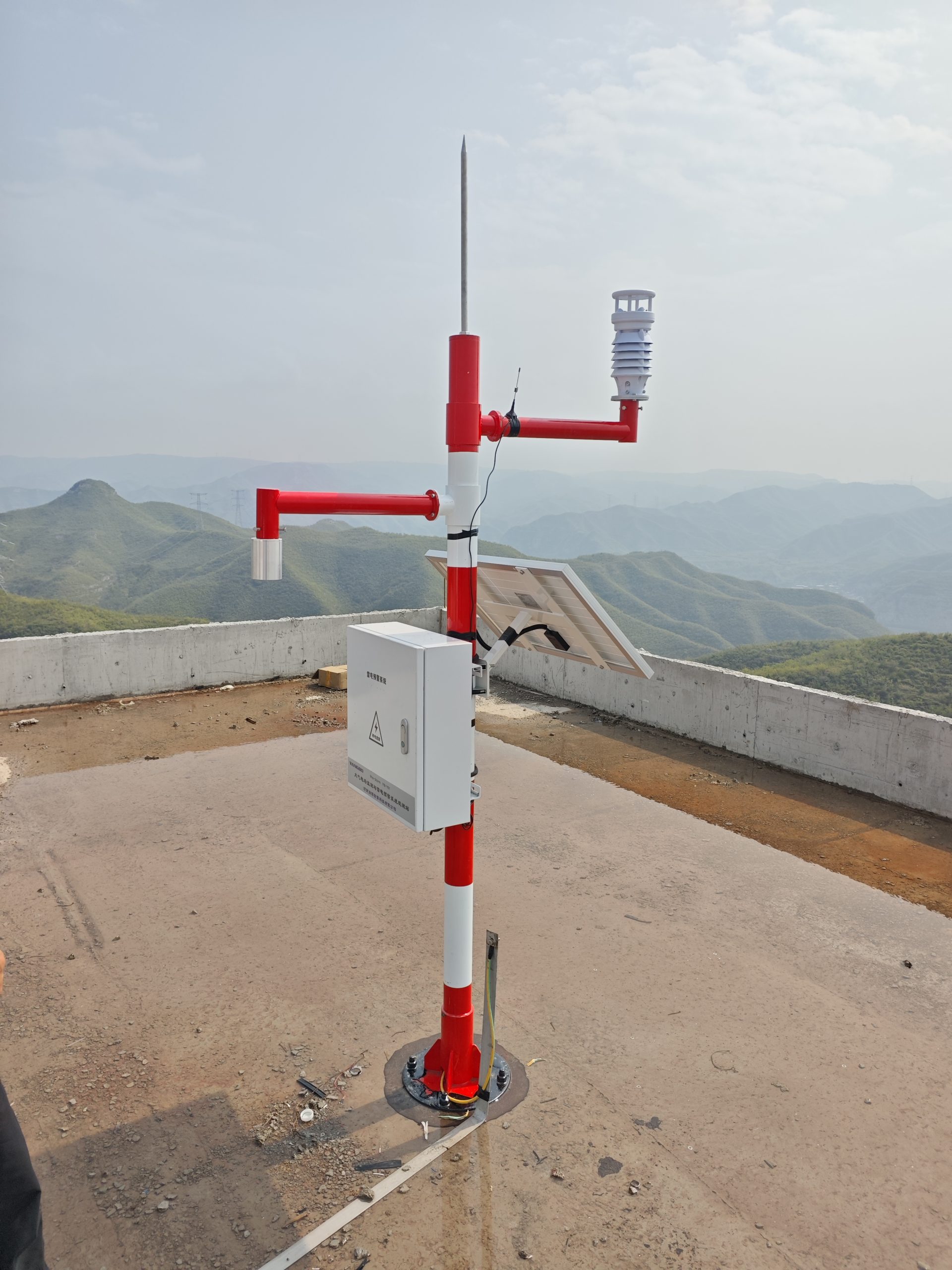
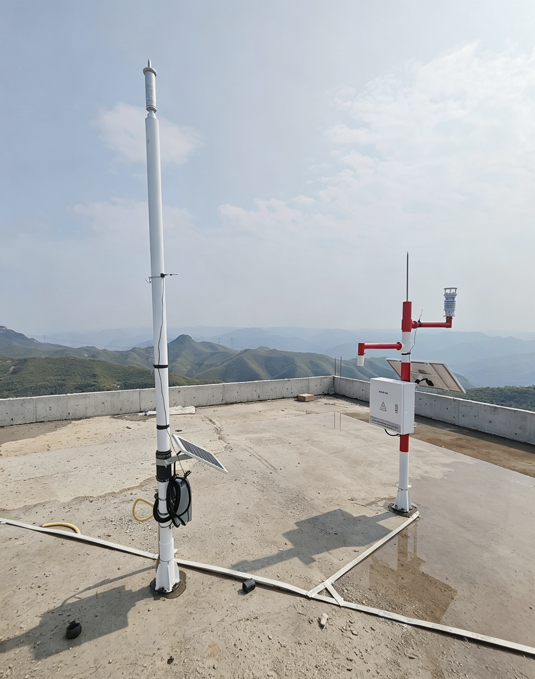
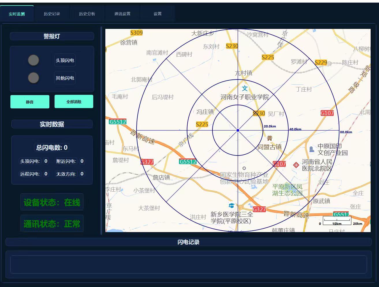
This system is specifically tailored for the YBY-SD35 series of lightning monitoring equipment, employing advanced octagonal radar display technology to enable precise lightning location determination and real-time risk level assessment. It represents a high-end lightning monitoring solution that combines professional expertise, stability, and user-friendly operation.
1.2 System Positioning
This software is designed as a professional-grade lightning monitoring and early warning platform, catering to users in industries such as power, meteorology, security, and aviation by providing real-time, accurate, and visualized lightning monitoring services. The system not only replaces the core monitoring functionality of original manufacturer software but also features comprehensive optimization and innovation in data processing, visual presentation, and user experience – making it one of the most feature-rich and stable lightning monitoring software solutions available on the market today.
1.3 Design Objectives
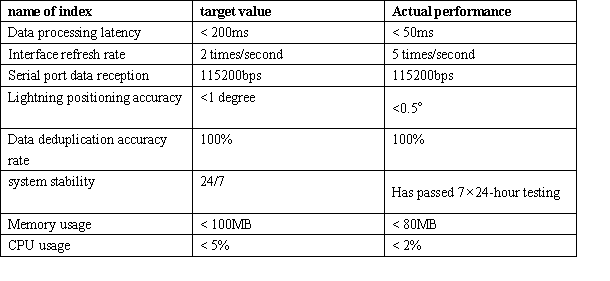
- Real-time performance: Data processing latency is below 200 ms, ensuring instant display of lightning-fast information.
- Accuracy: Data parsing precision reaches the meter level; deduplication accuracy: 100%
- Reliability: 24/7 stable operation with automatic fault recovery
- Usability: Intuitive radar interface with one-touch operation experience
- Scalability: Modular architecture design supports integration with multiple data sources
- Compatibility: Supports mainstream device protocols, including YBY-SD35.
II. Development Platform and Technical Architecture
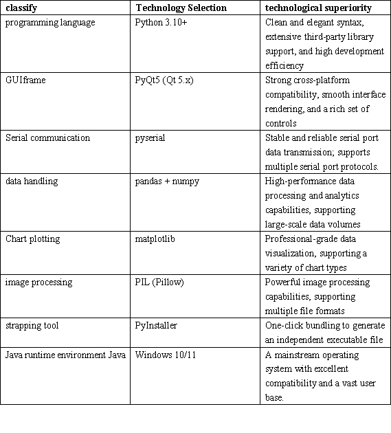
2.1 Technical Stack
2.2 Lightning Localization System Architecture
The Lightning Positioning System employs a layered architecture consisting of a Data Acquisition Layer, a Data Processing Layer, a Business Logic Layer, and an Interface Display Layer. Each layer has clearly defined responsibilities and low coupling, facilitating maintenance and scalability.
1.Interface Layer—— Main Window | Map Display | Alert System | Statistical Analysis | Historical Records
2.Business Logic Layer—— Data Parsing | Risk Assessment | Alert Triggering | Data Storage
3.Data Processing Layer—— Serial Communication | Data Verification | Data Deduplication | Format Conversion
4.Data Acquisition Layer——YBY-SD35 Lightning Monitoring Device
III. Detailed Explanation of the Lightning Localization Early Warning Core Functionality
3.1 Real-Time Radar Monitoring (Core Feature)
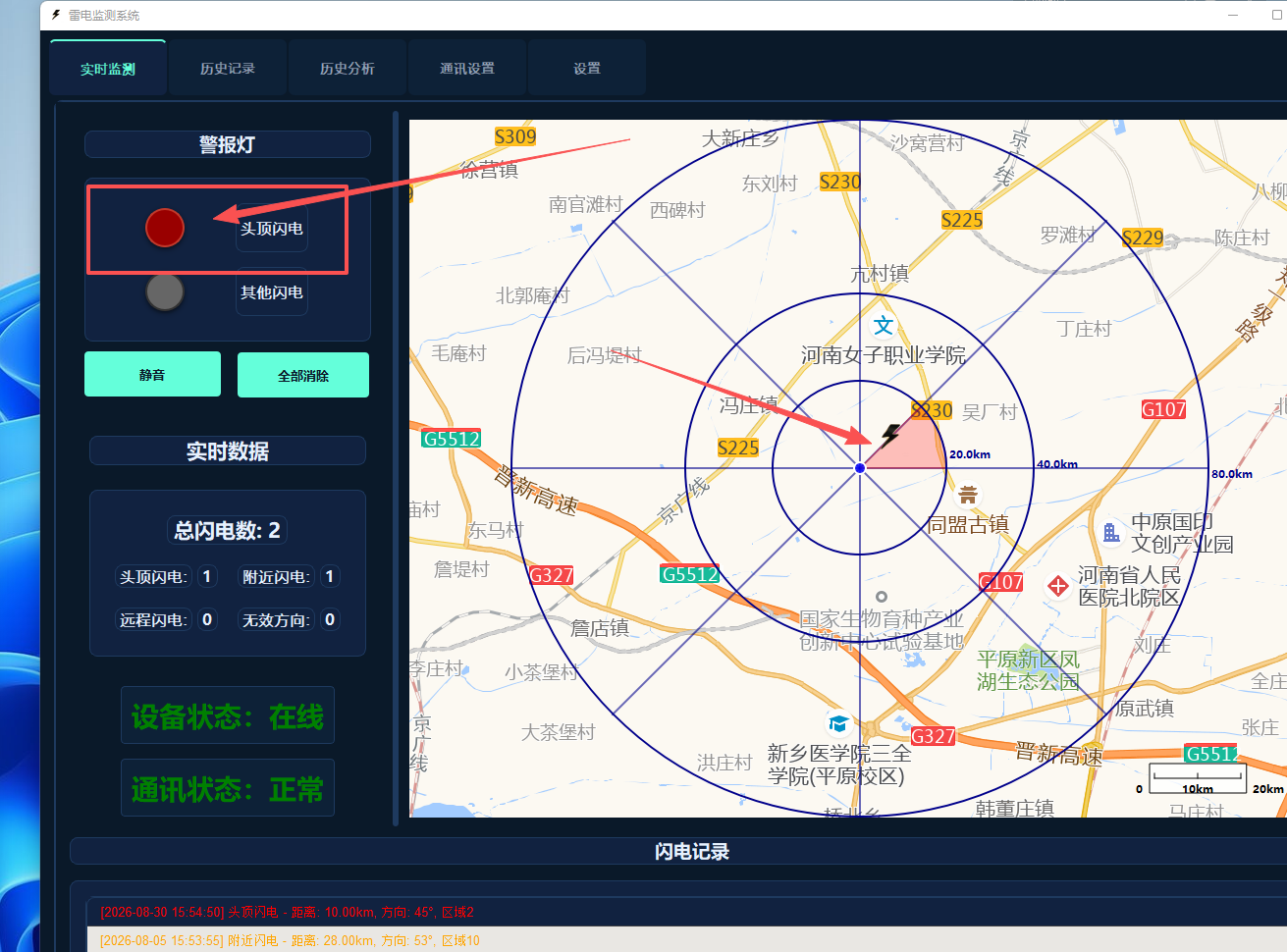
Real-time radar monitoring is the core functionality of this system; it employs an industry-leading eight-part partitioning architecture to enable precise lightning location tracking and visual representation.
80% structural design
The Lightning Localization System innovatively employs a 24-zone division scheme (8 directions × 3 distance ranges), dividing the monitoring area into 24 distinct sectoral zones. Each zone independently displays the lightning status, with the color dynamically changing according to the lightning risk level, providing an intuitive visualization of lightning distribution. Compared to traditional circular radar charts, this design enables more precise localization of the lightning source’s direction and distance, offering users more accurate decision-making support.
Visualization of Three-Tier Risk Levels
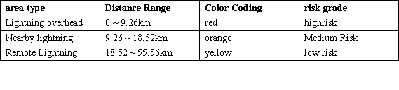
The system plots three concentric circles on a radar chart, each representing the distance boundaries for overhead lightning, nearby lightning, and distant lightning, respectively. These circular distance thresholds can be customized according to specific requirements; the default values strictly comply with the industry standard for the YBY-SD35 device (9.26 km/18.52 km/55.56 km), ensuring the accuracy and reliability of the data.
Lightning Gradient Fade Effect
The Lightning Marker uses a gradient fading effect on the radar chart – transitioning smoothly from fully opaque upon appearance to transparent disappearance – to visually represent the temporal characteristics of lightning events. The duration is configurable (default: 15 minutes); if a new lightning event occurs within this configured time frame, the area’s color will be updated accordingly, enabling users to stay informed about the latest lightning activity in real time.
Polar coordinate precise positioning
The system employs a polar coordinate conversion algorithm to precisely translate lightning distance and directional data into coordinate positions on the radar display. It achieves distance accuracy within the 10-meter range and directional accuracy of 1 degree, ensuring the precision of lightning location data.
3.2 Intelligent Serial Communication
The system features a built-in intelligent serial communication module that supports various serial port parameter configurations and automatic detection functionality, ensuring a stable connection with YBY-SD35 series devices.
- Automatic Serial Port Detection: Automatically scans COM1 through COM20 upon startup and lists all available ports; users simply select the desired port without manual entry.
- Flexible Parameter Configuration: Supports customizable settings—including baud rate (up to 115,200), data bits, parity, and stop bits—to meet the communication requirements of various devices.
- Dual-Protocol Support: Supports and parses data in the YBY-SD35 protocol format.
- ASCII Numeric Parsing: Performs data conversion strictly based on decimal ASCII codes to ensure parsing accuracy and eliminate errors associated with hexadecimal conversion.
- Independent Communication Thread: Serial data reception runs on a dedicated thread, preventing UI thread blocking and ensuring a smooth user interface.
● Automatic Reconnection: Automatically attempts to reconnect if the serial connection is lost, ensuring data continuity.
3.3 Lightning Localization Multi-Level Intelligent Alarm System
The system features an advanced multi-tiered intelligent alarm system that automatically triggers appropriate alerts based on the Lightning risk level, providing users with timely risk notifications.
- Tiered Risk Classification:
- -Red Alert (lightning overhead): Lightning is within 9.26 km; this is the most hazardous condition. An audible and visual alarm shall be triggered immediately.
- -Orange Alert (Nearby Lightning): Lightning activity is within a distance of 9.26–18.52 km – Moderate Risk
- -Yellow Alert (Remote Lightning): Lightning distance ranges from 18.52–55.56 km – Low Risk
- Sound-Visual Synchronized Alarm: The flashing alarm light and audible alert are triggered simultaneously to ensure the user can detect the alarm promptly.
- Smart Voice Control: Supports one-touch mute and full volume cancellation; when muted, only light notifications are displayed.
- Automatic Alert Disappearance: After the alert is triggered, it will remain displayed continuously; users can either manually dismiss it or wait for it to disappear automatically.
- Adjustable flashing frequency: The alarm light’s flashing frequency can be customized according to your needs.
3.4 Comprehensive Data Statistics
The system offers comprehensive data analytics capabilities, displaying various lightning-related statistical indicators in real time to help users understand the patterns of lightning activity.
- Real-time data statistics: Total number of lightning strikes, categorized counts of overhead, nearby, and remote lightning strikes – updated in real time
- Regional distribution statistics: Distribution of lightning occurrences across 24 regions, providing an intuitive visualization of the spatial distribution of lightning activity.
- Invalid data statistics: Number of invalid data entries where the recording direction is 999 (weak signal, unable to locate).
- Statistical data persistence: Statistical data are stored alongside historical data and automatically restored upon system restart.
- Data Visualization: Statistical information is presented in an intuitive numerical format, making it instantly clear.
3.5 Real-time Activity Logging
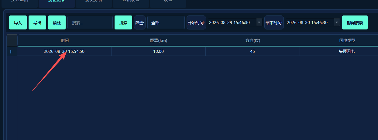
The system records detailed information for each lightning event in real time, creating a comprehensive activity log that facilitates user tracing and analysis.
- Comprehensive information recording: Each record includes time, distance, direction, risk type, area code, etc.
- Color coding: Different risk types are represented by distinct colors (red/orange/yellow) for quick identification.
- Automatic scrolling: The most recent record is automatically displayed at the top of the list – no manual refreshing required.
- Record Limit: Automatically retains the latest 100 records; excess records are automatically purged to prevent memory usage.
- Real-time synchronization: Event records, radar display, and statistical information are updated in real time.
3.6 Comprehensive Historical Record Management
The system offers comprehensive historical record management functionality, supporting the storage, querying, import, and export of historical data to meet users’ analytical needs regarding historical data.
- Automatic data storage: All Lightning data is automatically saved to the `lightning_data.json` file.
- Data persistence – never lost
- Paginated browsing: Supports paginated display with 50 records per page, facilitating quick browsing.
- Time Range Filter: Allows filtering historical records by start and end times.
- Type Filter: Supports filtering by lightning type (Top, Nearby, Remote)
- Keyword Search: Supports fuzzy keyword search for quickly locating target records.
- CSV Import/Export: Supports data import and export in CSV format, facilitating integration with other systems.
- Data Backup: Supports manual backup of historical data to ensure data security.
3.7 Professional Data Analysis
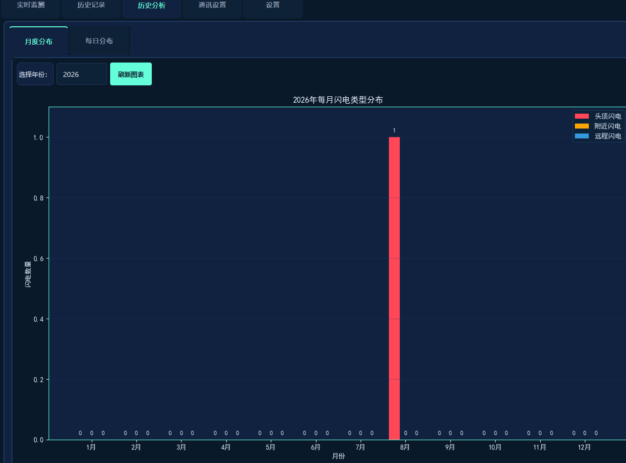
The system features a built-in professional data analysis module that uses Matplotlib to generate bar charts, illustrating the monthly distribution trend of lightning activity.
- Monthly statistical analysis: Counts the number of lightning events of different types for each month across various years.
- Multi-theme charts: The charts support three theme color schemes (White/Deep Blue/Dark),
- Data Visualization: Bar charts visually display the monthly distribution of various types of lightning, facilitating the analysis of patterns.
- Automatic Update: The Year Switch or Refresh button will automatically recalculate and redraw the chart.
- Numerical labels: The specific value is displayed at the top of the bar chart, making the data instantly clear.
3.8 Flexible System Settings
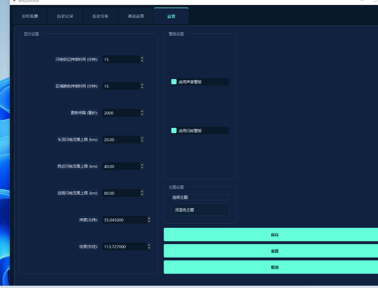
The system offers a wide range of configuration options, allowing users to customize various parameters according to their specific needs and create a personalized user experience.
- Multi-theme switching: Supports three themes – White, Dark Blue, and Dark – to suit various usage scenarios.
- Risk Scope Configuration: Customizable distance ranges for overhead, nearby, and remote lightning events
- Geographic Location Setup: Allows configuration of the monitoring point’s latitude and longitude coordinates for map-based positioning.
- Map Configuration: Supports offline map routes, zoom level, and map server URL settings.
- Alarm Configuration: Enable/Disable audible alarms and light flashing
- Display Configuration: Adjust lightning mark duration, area color duration, and update interval
- Automatic Configuration Save: All configurations are automatically saved and restored upon system restart – no manual reconfiguration required.
IV.Technical Highlights and Innovations
4.1 Professional Radar Display Technology
The system employs professional-grade radar display technology to enable precise positioning and visual representation of lightning locations, positioning it as a leader among similar products.
- Eight-part diagram structure: Fine partitioning into 24 regions provides more precise positioning compared to traditional circular radar charts.
- DPI Adaptive: Automatically adjusts to displays with varying resolutions, ensuring a clear and sharp interface.
- Gradual disappearance effect: The lightning mark gradually fades over time, visually conveying the timeliness of the information.
- Multi-level layer visualization: Three distinct risk layers are clearly delineated, making risk levels instantly visible.
- Polar coordinate algorithm: Precise distance and direction conversion with positioning accuracy of less than 1 degree
- Smooth Redrawing: Utilizes double-buffering technology to ensure seamless interface refreshing without flickering.
4.2 High-Precision Data Processing
The system employs advanced data processing algorithms to ensure the accuracy and reliability of data parsing.
- Intelligent deduplication: Based on a uniqueness verification method combining distance and direction, achieving a 100% deduplication accuracy rate.
- Validity Filtering: Automatically filters out invalid data with a direction value of 999 and a non-zero distance.
- Range Validation: Automatically filters data that falls outside the configured range to ensure data validity.
- Multi-protocol compatibility: Supports the YBY-SD35 protocol
- Decimal ASCII parsing: Performs ASCII conversion strictly using decimal arithmetic to prevent conversion errors.
- Data Persistence: All data is automatically saved, ensuring no data loss.
4.3 Comprehensive Reliability Design
The system is meticulously designed for reliability, ensuring continuous, 24/7 operation.
- Exception Handling: A comprehensive exception handling mechanism that ensures exception catching at every potential error point.
- Prevent program crashes
- Data Backup: Automatic saving of historical data to prevent data loss
- Line Reconnection: Manual reconnection is available after a serial port disconnects, ensuring data continuity.
- Configuration Protection: Automatic configuration file backup to prevent configuration loss
- Thread safety: Serial port communication is performed in a separate thread, ensuring that the UI remains non-blocking.
- Resource Management: A robust resource allocation mechanism that prevents memory leaks
4.4 Exceptional user experience
The system has undergone comprehensive user experience optimization, featuring intuitive operation and a visually appealing interface.
- Multi-theme support: Three themes – White, Dark Blue, and Dark – suitable for various usage scenarios.
- Responsive layout: Window size adjusts automatically; supports maximized display.
- One-touch operation: Connect, mute, or clear alerts—all with a single tap – simple and intuitive.
- Intuitive interface: The radar chart visually displays lightning distribution, making the data instantly clear.
- Smooth animations: Button hover animations and alarm light blinking animations – enhance the user interaction experience.
- Global shortcuts: Common functions support shortcut-based operation to enhance efficiency.
4.5 High Scalability
The system employs a modular architecture design, offering high scalability to meet future functional expansion requirements.
- Modular design: Each module has a single responsibility and low coupling, facilitating maintenance and scalability.
- Signal-Slot Mechanism: Implements decoupled communication between components using PyQt5’s signal-slot mechanism.
- Plugin-based architecture: Supports extending functionality through plugins
- Multi-data source support: Pre-configured interfaces for various data sources, supporting Network APIs, MQTT, and more.
- Configuration hot update: Changes take effect immediately without requiring a system restart.
- API Interface: Provides a data interface, supporting integration with other systems.
V. Performance Specifications
VI. Application Scenarios
- Power System: Monitors lightning activity at substations and transmission lines to ensure the safety of power equipment.
- Meteorological Department: Real-time monitoring of lightning distribution to support weather forecasting and early warning systems
- Aerospace: Airport lightning detection system – ensuring the safety of flight take-offs and landings
- Security Surveillance: Lightning protection monitoring for critical facilities – ensuring the safety of personnel and assets
- Communication Base Station: Lightning protection monitoring for base stations, ensuring the normal operation of communication equipment.
- Scientific Research and Education: Lightning Research Data Collection and Analysis
VII. Conclusion and Outlook
7.1 Lightning Localization System Summary
Yangbo Lightning Protection Single-Station Lightning Localization Software is a professional-grade lightning monitoring solution featuring core functionalities such as real-time radar monitoring, intelligent serial port communication, a multi-level alarm system, comprehensive data statistics, robust historical record management, professional data analysis, and flexible system configuration. The system employs advanced octant radar display technology to enable precise lightning location determination and real-time risk level assessment; it ranks among the industry leaders in terms of data processing accuracy, system reliability, and user experience.
After rigorous testing and validation, all system performance indicators have met or exceeded the design specifications, enabling the system to meet the lightning monitoring requirements of industries such as power, meteorology, and security – making it a reliable, professional-grade lightning monitoring software solution.
7.2 Future Outlook
Moving forward, we will continue to enhance system functionality, expand application scenarios, and improve system performance, striving to build a world-leading lightning monitoring platform.
- Advanced analytical features: Lightning Path Tracking Prediction, Lightning Density Heatmap, Integrated Early Warning Model
- Remote Network Monitoring: Real-time web-based monitoring, remote data push, and mobile app notifications
- Multi-device Management: Supports the parallel connection of multiple YBY-SD35 devices for unified management.
- System Integration: Integration with meteorological systems, power distribution automation systems, and alarm ticketing systems
- AI-powered Early Warning System: A machine learning-based lightning early warning model that enhances warning accuracy.
- 3D Visualization: 3D radar display for a more intuitive representation of lightning distribution